Uncertainties in Global Land-Use and Land-Cover Information
Information on global land use and land cover is crucial when studying changes in biodiversity, food security, climate, and many other contemporary issues, but suffers from widespread uncertainties. We - quantify and address these issues.
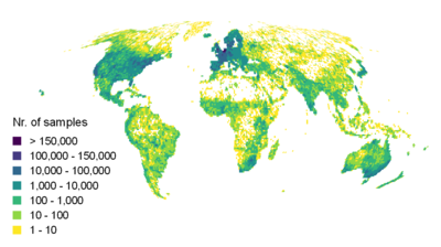
To achieve this, we are mobilizing ground-truth information from hundreds of sources worldwide, generated through field and crowdsourcing campaigns. To close gaps in data-scarce regions, we collaborate with hundreds of regional data-holding scientists on developing a FAIR and Open-Access database. On the top image to the right, we see the latest status of this effort. The map shows the global distribution of samples collected by the Macroecology & Society lab, composed millions of land cover and land use observations.
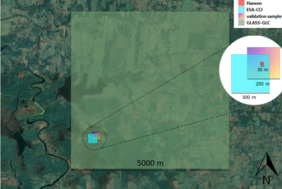
Using these integrated data, we detect, quantify, map, and ultimately aim to reduce uncertainties in land-cover land land-use, as well as in various derived environmental data. For example, we are developing a framework for uncertainty quantification of remotely sensed environmental data that accounts for scale mismatches between samples and pixels, such as seen on bottom image to the right. The image shows the spatial mismatch between the pixels of multiple, gridded land cover datasets, which create thematic uncertainties.
